
Page 637 - UAE National Geospatial Feature Catalogue
P. 637
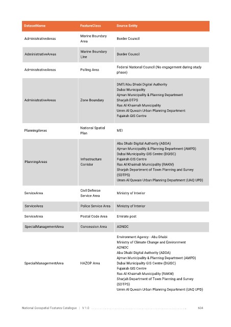
DatasetName                  FeatureClass       Source Entity

                                          Marine Boundary
              AdministrativeAreas                            Border Council
                                          Area

                                           Marine Boundary
              AdministrativeAreas                            Border Council
                                           Line

                                                             Federal National Council (No engagement during study
              AdministrativeAreas         Polling Area
                                                             phase)

                                                             DMT/Abu Dhabi Digital Authority
                                                             Dubai Municipality
                                                             Ajman Municipality & Planning Department
              AdministrativeAreas         Zone Boundary      Sharjah DTPS
                                                             Ras Al Khaimah Municipality
                                                             Umm Al Quwain Urban Planning Department
                                                             Fujairah GIS Centre

                                          National Spatial
              PlanningAreas                                  MEI
                                          Plan


                                                             Abu Dhabi Digital Authority (ADDA)
                                                             Ajman Municipality & Planning Department (AMPD)
                                                             Dubai Municipality GIS Centre (DGISC)
                                           Infrastructure    Fujairah GIS Centre
              PlanningAreas
                                           Corridor          Ras Al Khaimah Municipality (RAKM)
                                                             Sharjah Department of Town Planning and Survey
                                                             (SDTPS)
                                                             Umm Al Quwain Urban Planning Department (UAQ UPD)


                                          Civil Defense
              ServiceArea                                    Ministry of Interior
                                          Service Area

              ServiceArea                  Police Service Area   Ministry of Interior

              ServiceArea                 Postal Code Area   Emirate post

              SpecialManagementArea        Concession Area   ADNOC


                                                             Environment Agency - Abu Dhabi
                                                             Ministry of Climate Change and Environment
                                                             ADNOC
                                                             Abu Dhabi Digital Authority (ADDA)
                                                             Ajman Municipality & Planning Department (AMPD)
              SpecialManagementArea       HAZOP Area         Dubai Municipality GIS Centre (DGISC)
                                                             Fujairah GIS Centre
                                                             Ras Al Khaimah Municipality (RAKM)
                                                             Sharjah Department of Town Planning and Survey
                                                             (SDTPS)
                                                             Umm Al Quwain Urban Planning Department (UAQ UPD)


            National Geospatial Features Catalogue   |   V 1.0   . . . . . . . . .. . . . . . . . . . . . . . . . . . . . . . . . . . . . . . . . . . . . . . . . . . . . . . . . . . ..               604