
Page 233 - UAE National Geospatial Feature Catalogue
P. 233
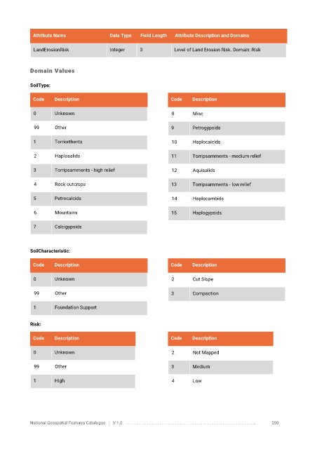
Attribute Name               Data Type   Field Length   Attribute Description and Domains

              LandErosionRisk             Integer     3            Level of Land Erosion Risk. Domain: Risk


            Domain Values

            SoilType:


             Code     Description                                Code    Description

              0       Unknown                                     8      Misc

              99      Other                                      9       Petrogypsids

              1       Torriorthents                               10     Haplocalcids


              2       Haplosalids                                11      Torripsamments - medium relief

              3       Torripsamments - high relief                12     Aquisalids

              4       Rock outcrops                              13      Torripsamments - low relief


              5       Petrocalcids                                14     Haplocambids

              6       Mountains                                  15      Haplogypsids

              7       Calcigypsids


            SoilCharacteristic:

             Code     Description                                Code    Description


              0       Unknown                                     2      Cut Slope

              99      Other                                      3       Compaction

              1       Foundation Support


            Risk:


             Code     Description                                Code    Description

              0       Unknown                                     2      Not Mapped

              99      Other                                      3       Medium


              1       High                                        4      Low


            National Geospatial Features Catalogue   |   V 1.0   . . . . . . . . .. . . . . . . . . . . . . . . . . . . . . . . . . . . . . . . . . . . . . . . . . . . . . . . . . . ..               200