
Page 83 - UAE National Geospatial Feature Catalogue
P. 83
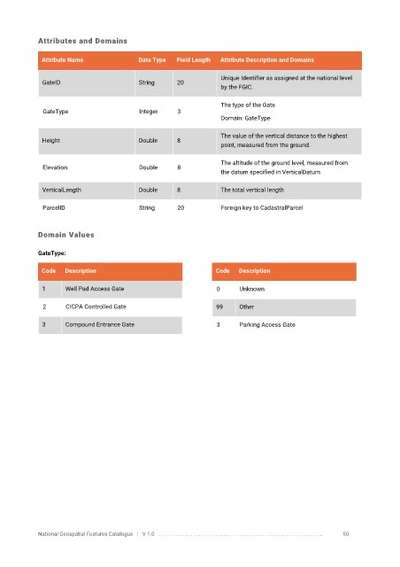
Attributes and Domains

             Attribute Name               Data Type   Field Length   Attribute Description and Domains


                                                                   Unique Identifier as assigned at the national level
              GateID                      String      20
                                                                   by the FGIC.

                                                                   The type of the Gate
              GateType                    Integer     3
                                                                   Domain: GateType


                                                                   The value of the vertical distance to the highest
              Height                      Double      8
                                                                   point, measured from the ground.

                                                                   The altitude of the ground level, measured from
              Elevation                   Double      8
                                                                   the datum specified in VerticalDatum

              VerticalLength              Double      8            The total vertical length

              ParcelID                    String      20           Foreign key to CadastralParcel


            Domain Values

            GateType:


             Code   Description                                  Code   Description

              1     Well Pad Access Gate                          0     Unknown

              2      CICPA Controlled Gate                       99     Other


              3     Compound Entrance Gate                        3     Parking Access Gate


            National Geospatial Features Catalogue   |   V 1.0   . . . . . . . . .. . . . . . . . . . . . . . . . . . . . . . . . . . . . . . . . . . . . . . . . . . . . . . . . . . ..               50