Page 592 - UAE National Geospatial Feature Catalogue
P. 592

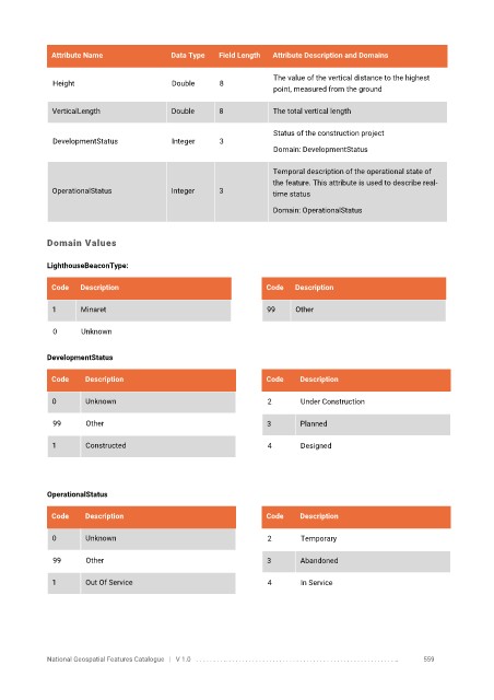
Attribute Name               Data Type   Field Length   Attribute Description and Domains

                                                                   The value of the vertical distance to the highest
              Height                      Double      8
                                                                   point, measured from the ground

              VerticalLength              Double      8            The total vertical length

                                                                   Status of the construction project
              DevelopmentStatus           Integer     3
                                                                   Domain: DevelopmentStatus

                                                                   Temporal description of the operational state of
                                                                   the feature. This attribute is used to describe real-
              OperationalStatus           Integer     3            time status

                                                                   Domain: OperationalStatus


            Domain Values

            LighthouseBeaconType:

             Code   Description                                  Code   Description


              1     Minaret                                      99     Other

              0      Unknown


            DevelopmentStatus

             Code     Description                                Code    Description


              0       Unknown                                     2      Under Construction

              99      Other                                      3       Planned

              1       Constructed                                 4      Designed


            OperationalStatus

             Code     Description                                Code    Description

              0       Unknown                                     2      Temporary


              99      Other                                      3       Abandoned

              1       Out Of Service                              4      In Service


            National Geospatial Features Catalogue   |   V 1.0   . . . . . . . . .. . . . . . . . . . . . . . . . . . . . . . . . . . . . . . . . . . . . . . . . . . . . . . . . . . ..               559
   587   588   589   590   591   592   593   594   595   596   597