
Page 144 - UAE National Geospatial Feature Catalogue
P. 144
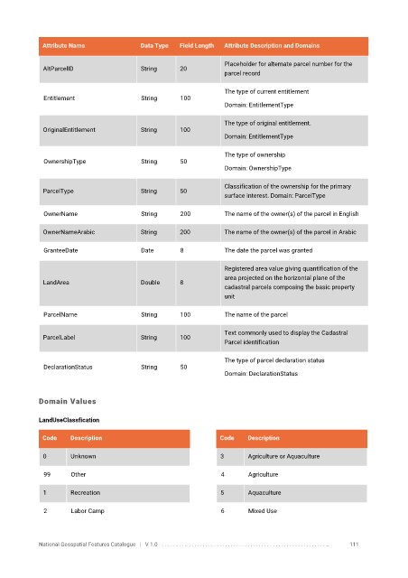
Attribute Name               Data Type   Field Length   Attribute Description and Domains

                                                                   Placeholder for alternate parcel number for the
              AltParcelID                 String      20
                                                                   parcel record

                                                                   The type of current entitlement
              Entitlement                 String      100
                                                                   Domain: EntitlementType


                                                                   The type of original entitlement.
              OriginalEntitlement         String      100
                                                                   Domain: EntitlementType


                                                                   The type of ownership
              OwnershipType               String      50
                                                                   Domain: OwnershipType

                                                                   Classification of the ownership for the primary
              ParcelType                  String      50
                                                                   surface interest. Domain: ParcelType

              OwnerName                   String      200          The name of the owner(s) of the parcel in English


              OwnerNameArabic             String      200          The name of the owner(s) of the parcel in Arabic

              GranteeDate                 Date        8            The date the parcel was granted

                                                                   Registered area value giving quantification of the
                                                                   area projected on the horizontal plane of the
              LandArea                    Double      8
                                                                   cadastral parcels composing the basic property
                                                                   unit


              ParcelName                  String      100          The name of the parcel

                                                                   Text commonly used to display the Cadastral
              ParcelLabel                 String      100
                                                                   Parcel identification

                                                                   The type of parcel declaration status
              DeclarationStatus           String      50
                                                                   Domain: DeclarationStatus


            Domain Values


            LandUseClassfication

             Code     Description                                Code    Description

              0       Unknown                                    3       Agriculture or Aquaculture


              99      Other                                       4      Agriculture

              1       Recreation                                 5       Aquaculture

              2       Labor Camp                                  6      Mixed Use


            National Geospatial Features Catalogue   |   V 1.0   . . . . . . . . .. . . . . . . . . . . . . . . . . . . . . . . . . . . . . . . . . . . . . . . . . . . . . . . . . . ..               111