
Page 494 - UAE National Geospatial Feature Catalogue
P. 494
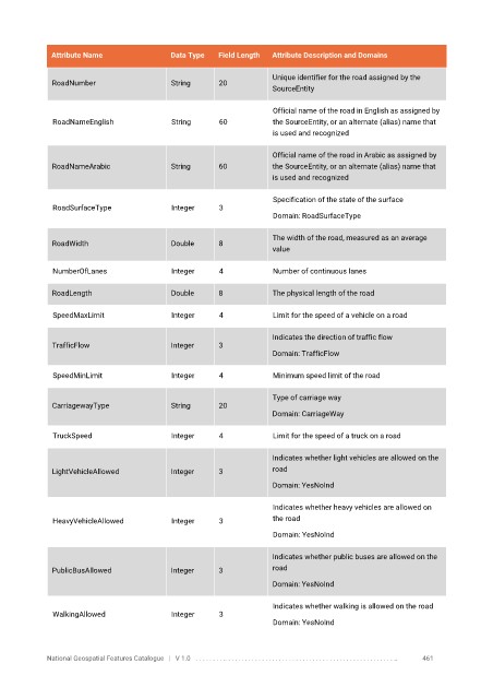
Attribute Name               Data Type   Field Length   Attribute Description and Domains

                                                                   Unique identifier for the road assigned by the
              RoadNumber                  String      20
                                                                   SourceEntity

                                                                   Official name of the road in English as assigned by
              RoadNameEnglish             String      60           the SourceEntity, or an alternate (alias) name that
                                                                   is used and recognized


                                                                   Official name of the road in Arabic as assigned by
              RoadNameArabic              String      60           the SourceEntity, or an alternate (alias) name that
                                                                   is used and recognized

                                                                   Specification of the state of the surface
              RoadSurfaceType             Integer     3
                                                                   Domain: RoadSurfaceType

                                                                   The width of the road, measured as an average
              RoadWidth                   Double      8
                                                                   value

              NumberOfLanes               Integer     4            Number of continuous lanes


              RoadLength                  Double      8            The physical length of the road

              SpeedMaxLimit               Integer     4            Limit for the speed of a vehicle on a road

                                                                   Indicates the direction of traffic flow
              TrafficFlow                 Integer     3
                                                                   Domain: TrafficFlow


              SpeedMinLimit               Integer     4            Minimum speed limit of the road

                                                                   Type of carriage way
              CarriagewayType             String      20
                                                                   Domain: CarriageWay

              TruckSpeed                  Integer     4            Limit for the speed of a truck on a road

                                                                   Indicates whether light vehicles are allowed on the
              LightVehicleAllowed         Integer     3            road
                                                                   Domain: YesNoInd


                                                                   Indicates whether heavy vehicles are allowed on
              HeavyVehicleAllowed         Integer     3            the road
                                                                   Domain: YesNoInd

                                                                   Indicates whether public buses are allowed on the
              PublicBusAllowed            Integer     3            road
                                                                   Domain: YesNoInd


                                                                   Indicates whether walking is allowed on the road
              WalkingAllowed              Integer     3
                                                                   Domain: YesNoInd


            National Geospatial Features Catalogue   |   V 1.0   . . . . . . . . .. . . . . . . . . . . . . . . . . . . . . . . . . . . . . . . . . . . . . . . . . . . . . . . . . . ..               461