Page 158 - UAE National Geospatial Feature Catalogue
P. 158

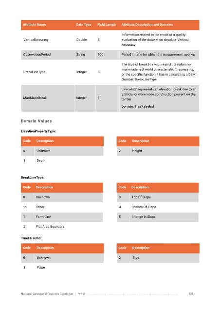
Attribute Name               Data Type   Field Length   Attribute Description and Domains

                                                                   Information related to the result of a quality
              VerticalAccuracy            Double      8            evaluation of the dataset on absolute Vertical
                                                                   Accuracy


              ObservationPeriod           String      100          Period in time for which the measurement applies

                                                                   The type of break line with regard the natural or
                                                                   man-made real world characteristic it represents,
              BreakLineType               Integer     3
                                                                   or the specific function it has in calculating a DEM.
                                                                   Domain: BreakLineType


                                                                   Line which represents an elevation break due to an
                                                                   artificial or man-made construction present on the
              ManMadeBreak                Integer     3            terrain

                                                                   Domain: TrueFalseInd


            Domain Values


            ElevationPropertyType:

             Code    Description                                 Code    Description

              0      Unknown                                     2       Height


              1      Depth


            BreakLineType:

             Code   Description                                  Code   Description


              0     Unknown                                      3      Top Of Slope

              99     Other                                        4     Bottom Of Slope

              1     Form Line                                    5      Change In Slope


              2      Flat Area Boundary


            TrueFalseInd:

             Code    Description                                 Code    Description

              0      Unknown                                     2       True


              1      False


            National Geospatial Features Catalogue   |   V 1.0   . . . . . . . . .. . . . . . . . . . . . . . . . . . . . . . . . . . . . . . . . . . . . . . . . . . . . . . . . . . ..               125
   153   154   155   156   157   158   159   160   161   162   163